
A first step in a community’s recovery after a traumatic event, such as an armed conflict, mass disaster, or pandemic, is to account for and identify all the lives lost in the tragedy. In many cases these individuals are buried in mass graves that may be either unmarked or deliberately concealed.
The discovery and documentation of mass graves has long been a difficult yet critical component of securing justice. After any mass fatality event, it is fundamental for the community’s reconciliation to identify the location of mass graves and return the missing to their loved ones, who have been denied the opportunity for customary death rituals.
In additional to customary rituals, it is important to a community and relatives of the dead to receive death certificates, which may be needed for legal transactions. Some loved ones are unable to transfer property, receive compensation, if available, or even re-marry if such documents are not provided. Finally, many entities have interests in collecting forensic evidence from mass graves to determine what has occurred and, if crimes were committed, investigate and prosecute those responsible.
Traditionally, mass graves have been located based on personal accounts of survivors and extensive searches for potential burial sites for further probing or exhumation. Yet, conducting physical searches for mass grave locations based on anecdotal evidence is a time-consuming and resource-intensive endeavour in circumstances that may pose a threat to personal safety.
The development of new tools and methods to speed up such searches are needed to reduce the risk involved, increase the number of individuals whose remains are recovered and identified, and, more importantly, reunite more individuals with their loved ones to provide them with a proper burial and access to justice.
Several technology-dependent methods have been used in the past to predict grave locations, albeit with varying degrees of success. Typically, geoscience approaches have utilized archaeological techniques combined with techniques from other disciplines. Hyperspectral analysis has been used to detect the signatures of decomposing bodies and surrounding vegetation from satellite imaging, though this is costly, and inaccessible to most organizations.
Another example comes from the Human Rights Data Analysis Group and Universidad Iberoamericana, which created a machine learning model that aggregates news reports and personal accounts to predict the state with the highest number of mass graves. This is a promising model to ensure energy is focused is in the right area, though it lacks the granularity needed to pinpoint grave locations.
GIS and predictive modelling
Other approaches have focused on spatial analysis using geographic information systems to create predictive and deductive models to find clandestine graves. These studies look into the characteristics of known mass graves and features related to their location to make inferences regarding why such locations were chosen.
As part of the requirements for my degree in Forensic Science at Virginia Commonwealth University (VCU), I conducted further research on using GIS to locate mass graves, with an emphasis on using open source tools and data. My research was inspired by my personal experiences and events I witnessed during the violence in my hometown of Matamoros, Tamaulipas. Located at the most southeastern border of the United States and Mexico Matamoros sees extremely high levels of violence. Since 2006, violence has grown exponentially and disappearances have become a daily occurrence, placing a heavy emotional burden on the community
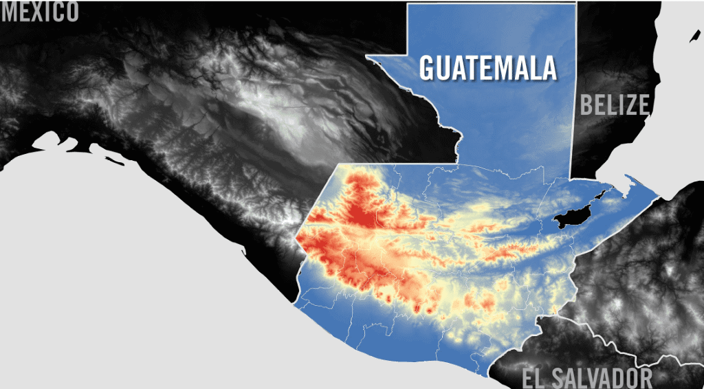
My research, supported by VCU and Amnesty International, examined geographic information and spatial characteristics of known mass graves in Guatemala from their internal armed conflict (1960’s – 1980’s) and analyzed patterns that might predict the location of other mass graves that have yet to be discovered.
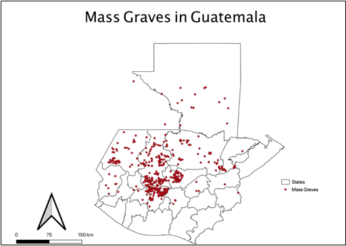
Using QGIS, a free and open source application that supports viewing, editing, and analysis of geospatial data, we were able evaluate the characteristics of numerous geographic features relative to the location of the nearest known mass grave.
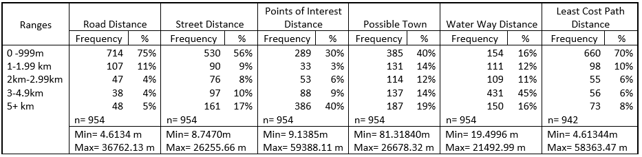
Such potentially predictive parameters included the placement of roads, waterways, some points of interest (community structures, such as churches, plazas, etc.), as well as administrative boundaries. These were chosen based on their availability in an open source format as well as the commonality of such features worldwide, which will allow this research to be replicated and cost-effective.
For example, we sourced road data from the OpenStreetMap project and a digital elevation file from the shuttle radar topography mission and calculated the distance and change in elevation between each mass grave and the nearest road. Using QGIS’s 3D rendering ability, we were able to create a map to better understand the relationship between these variables.
This approach allowed us to make more focused predictions for searches (eliminating over 90% of the land mass), providing a powerful tool for predicting mass grave locations and increasing the speed and efficacy with which they are investigated.
What is still needed?
This research lays the foundation for a more detailed predictive model of mass grave locations that can be created with an increased list of predictive variables. There are many shortfalls in data availability to be addressed, including the lack of access to information. For example, some organizations are reluctant to share their full databases on mass graves (due, for example, to ongoing prosecutions) and still other information exists only in proprietary or analogue formats.
More detailed research and perhaps even original data collection is required relating to soil types, tree coverage –whether from satellite imagery or drones — social media accounts of disappearances, and known mass grave locations. Even more important is information linking specific groups or perpetrators to known graves, which may well elucidate patterns of body disposal that purely geographic analysis might miss.
Comparing the results of research on mass graves in one country to other countries with similar conflicts will also yield new insights and potentially provide corroboration for the methods used. By assembling the right data and models, we can eliminate large regions that are unlikely to be the sites of clandestine graves, and thus do not need to be searched. Such an approach will provide human rights researchers, criminal investigators, and families seeking justice a powerful new suite of tools, many of which can be deployed from the safety of a workstation.
Perla Santillán was born in the city of Matamoros, Tamaulipas, Mexico. She received her Bachelor of Arts in Biological Anthropology from the University of Texas at Austin in 2013. She spent the next five years working in disaster relief for the American Red Cross, in different positions and states. In 2020 Perla earned a M.Sc. in Forensic Science with a concentration of physical evidence from Virginia Commonwealth University.